
 .................................................................................................................................................


Region I – Anatolia
Geography

Figure 1. Geographical map of Turkey.
Ia. Marmara
Subregion Ia is covering mainly the southern and eastern coastal areas of the Sea of Marmara, from north of the Gulf of Edremit in the southwest to the Sakarya River in the east (Figure 1). Of special importance are the lakes south of the Marmara next to which the prehistoric sites are situated. The narrow strip of land between the Marmara and the Black Sea is also included here: the known sites are close to bays and lakes directly connected to the Marmara, among them the Bosporus with the "Golden Horn" and the lakes of Kücük- and Büyükçekmeçe directly west of it. The northern shores of the Marmara we have taken to be part of Turkish (or Eastern) Thrace (Region IV), basically on cultural grounds.
Ib. Pontic Anatolia
East of the Sakarya River and even farther east only few prehistoric sites have been detected.
Ic. Central Anatolia
The Anatolian Plateau north of the Middle Taurus mountain range (Orta Toroslar) includes the areas of Konya and Cappadocia. This highland with no direct access to the sea, neither to the Mediterranean nor to the Aegean, today is characterised by a steppe vegetation. To the west the watershed determined by the mountainous chain of the Akdağları in the south, the Dedegöl Dağları between the Beyşehir and Eğirdir lakes in the west, and the Murat Dağı in the north, serves as a geographical boundary towards the Lake District (Göller Bölgesi) of southwestern Anatolia (Region Ie). The Tahtalı Dağları define the border towards Southeast Anatolia. The winding course of the Kızılırmak River does not form a strict boundary towards the north.
Id. Mediterranean Anatolia
South of the Taurus Mountains, from the Akdağları in the west to the Amanos Dağları in the east, large plains were formed around the Gulf of Antalya (plain of Pamphylia), and in the Mersin area (the Çukurova). They both connect through river valleys to the Anatolian highland: the Aksu Çayı of the Antalya region is crossing the whole of the Lake District, whereas the Seyhan River in the east is draining the northwestern flanks of the Tahtalı Dağları before reaching the coastal plain.
Ie. Southwest Anatolia
Often called the Lake District (or Göller Bölgesi) this area is situated between the West Anatolian catchment draining on the Aegean and the steppe country of the Konya region (Central Anatolia). The western Taurus Mountains (Batı Toroslar) form a natural border towards the south. The plain farther south around the Gulf of Antalya (Antalya Körfezi) is subsumed under Subregion Id.
Towards the east the chain of mountains between the Akdağları in the south, the Dedegöl Dağları between the two lakes Beyşehir and Eğirdir, and the Murat Dağı in the north, is part of the watershed that separates Central Anatolia (Subregion Ic) from Southwest Anatolia and serves as a geographical boundary between these two distinct regions. In the west the headwaters of the major E–W flowing rivers (Gediz, Küçük Menderes, and Büyük Menderes) are connecting this area with the coastal area of the Aegean (Region II).
Sites (n=33)
| Ia: Marmara | Ib: Pontic Anatolia | Ic: Central Anatolia |
Id: Mediterranean Anatolia | Ie: Southwest Anatolia |
| Aktopraklık | İkiztepe I | Alişar Höyük | Karain | Bademağacı |
| Barcın Höyük | İkiztepe II | Aşıklı Höyük | Mersin (Yumuktepe) | Hacılar |
| Ilıpınar | Boğazköy-Büyükkaya | Öküzini | Höyücek | |
| Menteşe | Canhasan I | Kuruçay | ||
| Yarımburgaz | Canhasan III | |||
| Yenikapı | Çadır Höyük | |||
| Çamlıbel Tarlası | ||||
| Çatalhöyük East | ||||
| Çatalhöyük West | ||||
| Erbaba | ||||
| Güvercinkayası | ||||
| Kaletepe | ||||
| Köşk Höyük | ||||
| Musular | ||||
| Pınarbaşı Site A | ||||
| Pınarbaşı Site B | ||||
| Suberde | ||||
| Tepecik-Çiftlik |
Geography
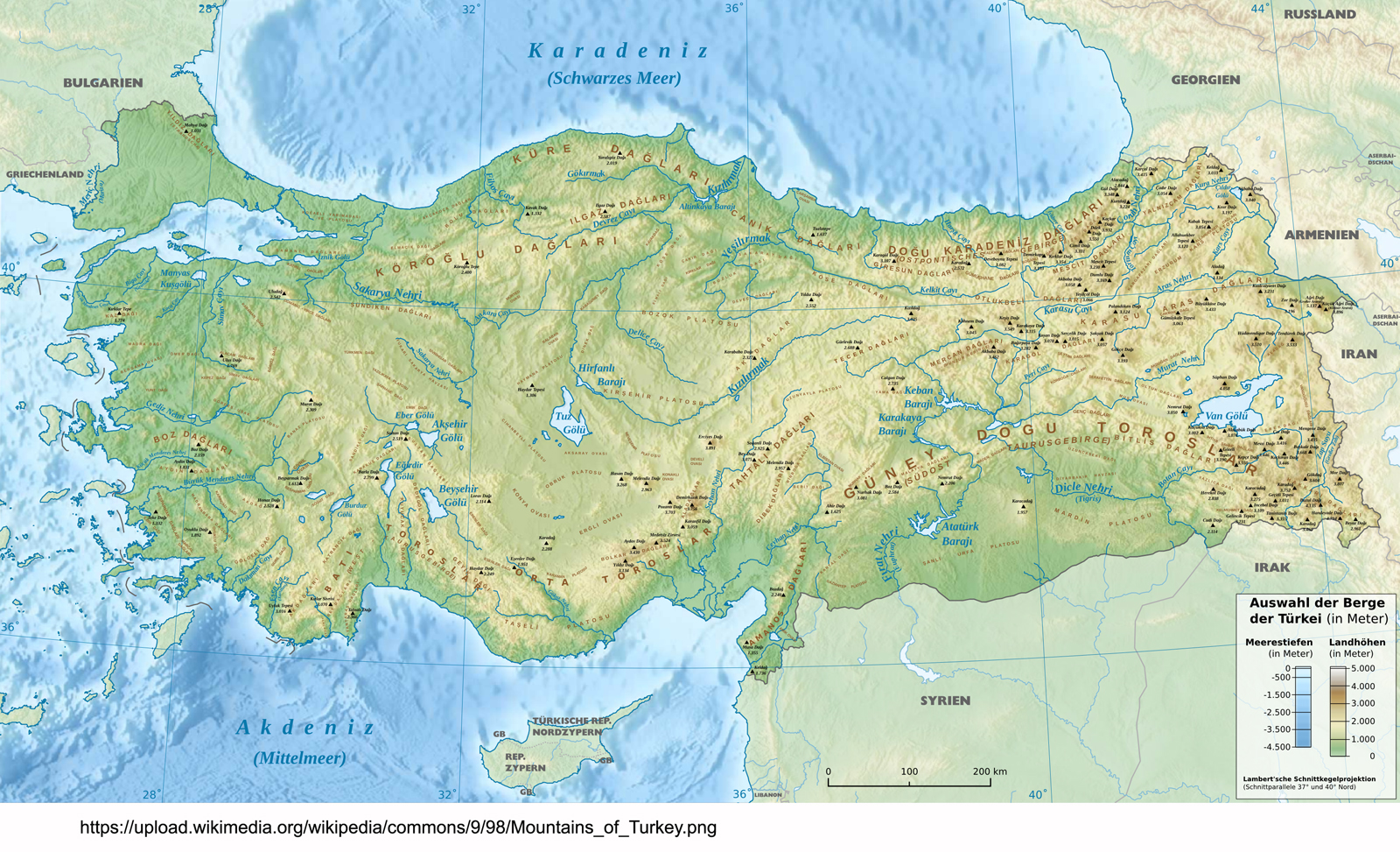
Figure 1. Geographical map of Turkey.
Ia. Marmara
Subregion Ia is covering mainly the southern and eastern coastal areas of the Sea of Marmara, from north of the Gulf of Edremit in the southwest to the Sakarya River in the east (Figure 1). Of special importance are the lakes south of the Marmara next to which the prehistoric sites are situated. The narrow strip of land between the Marmara and the Black Sea is also included here: the known sites are close to bays and lakes directly connected to the Marmara, among them the Bosporus with the "Golden Horn" and the lakes of Kücük- and Büyükçekmeçe directly west of it. The northern shores of the Marmara we have taken to be part of Turkish (or Eastern) Thrace (Region IV), basically on cultural grounds.
Ib. Pontic Anatolia
East of the Sakarya River and even farther east only few prehistoric sites have been detected.
Ic. Central Anatolia
The Anatolian Plateau north of the Middle Taurus mountain range (Orta Toroslar) includes the areas of Konya and Cappadocia. This highland with no direct access to the sea, neither to the Mediterranean nor to the Aegean, today is characterised by a steppe vegetation. To the west the watershed determined by the mountainous chain of the Akdağları in the south, the Dedegöl Dağları between the Beyşehir and Eğirdir lakes in the west, and the Murat Dağı in the north, serves as a geographical boundary towards the Lake District (Göller Bölgesi) of southwestern Anatolia (Region Ie). The Tahtalı Dağları define the border towards Southeast Anatolia. The winding course of the Kızılırmak River does not form a strict boundary towards the north.
 up
upId. Mediterranean Anatolia
South of the Taurus Mountains, from the Akdağları in the west to the Amanos Dağları in the east, large plains were formed around the Gulf of Antalya (plain of Pamphylia), and in the Mersin area (the Çukurova). They both connect through river valleys to the Anatolian highland: the Aksu Çayı of the Antalya region is crossing the whole of the Lake District, whereas the Seyhan River in the east is draining the northwestern flanks of the Tahtalı Dağları before reaching the coastal plain.
Ie. Southwest Anatolia
Often called the Lake District (or Göller Bölgesi) this area is situated between the West Anatolian catchment draining on the Aegean and the steppe country of the Konya region (Central Anatolia). The western Taurus Mountains (Batı Toroslar) form a natural border towards the south. The plain farther south around the Gulf of Antalya (Antalya Körfezi) is subsumed under Subregion Id.
Towards the east the chain of mountains between the Akdağları in the south, the Dedegöl Dağları between the two lakes Beyşehir and Eğirdir, and the Murat Dağı in the north, is part of the watershed that separates Central Anatolia (Subregion Ic) from Southwest Anatolia and serves as a geographical boundary between these two distinct regions. In the west the headwaters of the major E–W flowing rivers (Gediz, Küçük Menderes, and Büyük Menderes) are connecting this area with the coastal area of the Aegean (Region II).