
 .................................................................................................................................................


Region IV – Eastern Balkans
Geography
The Eastern Balkans are situated between the Danube Delta, the Bosporus and the arc described by the Southern Carpathians extending across the Danube Gorge into the Serbian Carpathians and linking with the Rila Massif to the Rhodope Mountains. The chain of mountains described by the Vitosha, Rila and Pirin (Figure 1) are forming the boundaries towards the Central Balkans (Region III). Thus, the Rhodope Mountains and the catchment of the upper Mesta/Nestos River are included in Region IV.
Region IV is also horizontally divided by the Balkan Mountains (Stara Planina) into a southern and a northern part. The southern part, namely Thrace (Subregion IVa), is drained by the rivers Tundzha, Maritsa, Arda and Ergene. In the northern part the Danube is draining both the southern Carpathians and the northern Balkans. Yet, the Lower Danube area is far from being a homogeneous region. According to climate and vegetation three main subregions must be differentiated: the western Lower Danube area (west of the Vedea-Yantra rivers) with a largely temperate climate (Subregion IVc); the eastern Lower Danube area of steppe vegetation (Subregion IVd), and the hilly Ludogorie Plateau east and including the Yantra River (Subregion IVb). The Kamchiya River and the Stara Planina can be seen as their southern boundaries, and it is in this area that the Pontic steppe is ending, only followed to the south by the West Pontic coastal stripe (Subregion IVe).
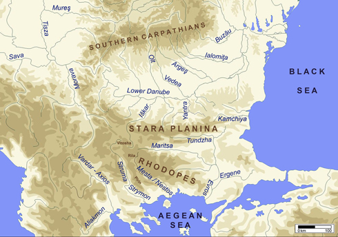
Figure 1. Geographical map of the central and eastern Balkans
Sites (n=94)
| IVa: Thrace | IVb: Ludogorie-Yantra | IVc: Lower Danube West | IVd: Lower Danube East | IVe: West Pontic |
| Așağı Pınar | Džuljunica-Smǎrdeš | Ajmana | Bucșani | Akladi Cheiri |
| Bikovo (Dončova Mogila) | Hotnica-Orlovka | Alibeg | Căscioarele-Ostrovel | Durankulak |
| Čavdar | Hotnica, Tell | Bezhanovo | Cernavodă | Goljamo Delčevo |
| Dolno Dryanovo | Hotnica-Vodopada | Borovan | Ciulniţa | Poveljanovo I |
| Dolnoslav | Kačica (Veliko Tȃrnovo) | Cârcea-Viaduct | Gumelniţa | Varna Cemetery |
| Drama-Gerena | Koprivec | Copăcelu-Valea Răii | Hârșova | |
| Drama-Merdžumekja | Omurtag | Cuina Turcului | Košarna | |
| Ezero (Tell Dipsis) | Ovčarovo | Curmătura | Lișcoteanca-Movila Olarului | |
| Haramijska dupka | Ovčarovo-gorata (Ruec) | Devetaki | Pietrele | |
| Hlebozavoda | Ovčarovo-platoto | Fărcașu de Sus | Radovanu | |
| Jagodina (Jagodinska peštera) | Poljanica | Galatin-Čukata | Seciu (Prahova) | |
| Jassatepe | Poljanica-platoto | Gornea | Tell Russe | |
| Junacite | Samovodene | Hajdučka Vodenica | Vărăști | |
| Karnobat | Smjadovo | Icoana | ||
| Kazanlăk | Krivodol | |||
| Orlitsa | Lăceni-Teleor 008 | |||
| Stara Zagora-Okražna Bolnica | Lepenski Vir | |||
| Tatul | Liubcova | |||
| Tell Azmak | Măgura-Boldul lui Moș Ivănuș | |||
| Tell Banjata (Kapitan Dimitrievo) | Măgura-Buduiasca | |||
| Tell Karanovo | Măgura Cave | |||
| Toptepe | Ohoden-Valoga | |||
| Varhari | Ostrovul Banului | |||
| Yabalkovo | Ostrovul Corbului | |||
| Ostrovul Mare | ||||
| Padina | ||||
| Petko Karavelovo | ||||
| Pipra | ||||
| Răzvrata | ||||
| Rudna Glava | ||||
| Sadovec-Ezero | ||||
| Sălcuţa | ||||
| Schela Cladovei | ||||
| Teliš (Teliš-Redutite) | ||||
| Vădastra | ||||
| Velešnica | ||||
| Vitănești | ||||
| Vlasac |
Geography
The Eastern Balkans are situated between the Danube Delta, the Bosporus and the arc described by the Southern Carpathians extending across the Danube Gorge into the Serbian Carpathians and linking with the Rila Massif to the Rhodope Mountains. The chain of mountains described by the Vitosha, Rila and Pirin (Figure 1) are forming the boundaries towards the Central Balkans (Region III). Thus, the Rhodope Mountains and the catchment of the upper Mesta/Nestos River are included in Region IV.
Region IV is also horizontally divided by the Balkan Mountains (Stara Planina) into a southern and a northern part. The southern part, namely Thrace (Subregion IVa), is drained by the rivers Tundzha, Maritsa, Arda and Ergene. In the northern part the Danube is draining both the southern Carpathians and the northern Balkans. Yet, the Lower Danube area is far from being a homogeneous region. According to climate and vegetation three main subregions must be differentiated: the western Lower Danube area (west of the Vedea-Yantra rivers) with a largely temperate climate (Subregion IVc); the eastern Lower Danube area of steppe vegetation (Subregion IVd), and the hilly Ludogorie Plateau east and including the Yantra River (Subregion IVb). The Kamchiya River and the Stara Planina can be seen as their southern boundaries, and it is in this area that the Pontic steppe is ending, only followed to the south by the West Pontic coastal stripe (Subregion IVe).

Figure 1. Geographical map of the central and eastern Balkans
 up
up