
 ...........................................................................................................


Subregion IIa – Eastern Aegean
The Neolithic period in the eastern Aegean region
The Anatolian-Aegean coastal areas have been the target of systematic research mainly in the last two decades. With the excavations in Ulucak (since 1995) and Çukuriçi Höyük (since 2006) the role of this region for the Neolithisation process in the whole of the Aegean world is becoming evident.
Çukuriçi
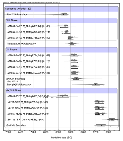
All radiocarbon dates from the basal deposits (Levels XIII–VIII) are on short-lived samples such as cereals, wheat, legumes, grass, and cattle, boar and goat bone, although details of the contexts are not yet published, and some of the samples suggest to be out of phase (MAMS-15270 and Erl-14513). Two samples on wheat from Level XIII are mutually exclusive on the 1σ level (MAMS-24431 and MAMS-24429), as are a sample of unidentified cereal from the same level (MAMS-24430) with MAMS-24429, implying either a series of events subsumed under XIII or contextual issues at play. The Level IX date (MAMS-15270) is identical in date with the earliest Level XIII date, and the sample must be residual in IX. In the boundary model (Amodel: 122), this Level IX date is treated as an outlier and subsumed as being part of Level VIII, while a gap of 300 years has been positioned between the end of XII and the start of VIII, a gap thus far devoid of radiocarbon evidence (Figure 1). The boundaries have been summarised in Table 1. Çukuriçi XIII would just predate the onset of settlement at Barcın Höyük, which would fall during the transition from Çukuriçi Level XIII to Level XII.
Ulucak
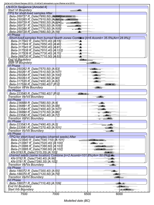
This site's radiocarbon evidence (n=38, to date) is complicated, and simply sequencing the dates according to the phasing yields an unsatisfactory model with very low agreement (Amodel: 4) (Figure 2). Short-lived samples on emmer from level VI possibly stem from the same event or from a short sequence of events, and are combined using the Combine command. Likewise, two charred seed samples from level Vb with same provenance (KN-5782 and KN-5781) have been combined. Both are taken to represent the time of destruction of their respective levels. Constraining the data further, we assume a gap of about 100 years between levels VI and Vf, justified on basis of the dates but also assumable given the differences between both levels (Çilingiroğlu et al. 2012, 14).
By treating a couple of dates deviating from the general chronological and sequential tendency, the Ulucak boundary model can be upgraded just a bit (Amodel: 32; Figure 3).
Table 2 has the simplified rendering of the last model.
Ege Gübre
The site (also known under its older name Çakmaklı Tepe) has four main phases:
The excavator's remark that "most of the artefacts were found in the IIIa and IIIb levels" and that "Layer IV was mostly scraped away by the activities that took place during Layer III" (Sağlamtimur 2012, 198), could at least suggest that the reliability of the dates assigned to Layer IV is questionable, and their phasing more prompted by their age than their stratigraphic context. Simultaneously, this situation is hard to reconcile with the excavator's statement that "none of the architectural phases are to be found on top of each other [...]" (l.c.). The "500-year life span" (l.c. and p. 201), obviously based on an uncritical interpretation of the 14C evidence, is hard to imagine when the pottery is stated to be "rather homogenous" in shape and technology, and vessel types differ only in relative proportions between Layers IV and III. Impresso pottery seems to have been present in both levels in very low quantities (ibid., 200). The lithic industry is mainly on blades, produced at the site, and is dominated by flint, with obsidian much less used. Animal bones consist mainly of sheep, goat and cattle, "pig being underrepresented" (ibid., 201).
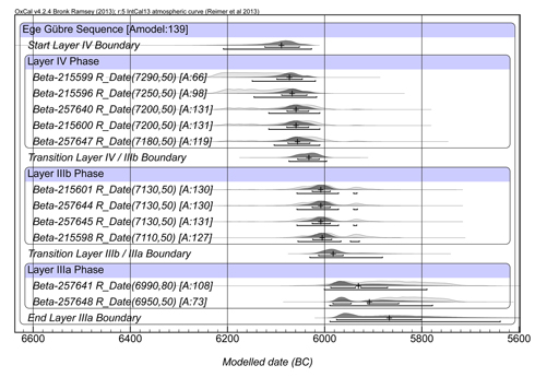
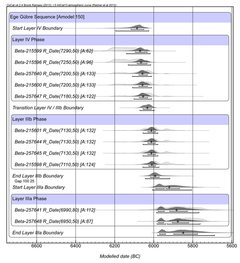
Most of the radiocarbon samples must have been collected from the central courtyard area (squares B2, C2, perhaps E1, E2 and D1, which are partly built), which had been used as a refuse area with a fill of 30–40 cm thick (ibid., 198); one sample stems from square E4, which is half covered by a segment of what is surmised to have been a stone protection wall erected against the repeated flooding of the Hayıtlı Çay. All dates are unidentified charcoal, therefore supplying termini post quos per individual level only (Amodel: 139; Figure 4). In contrast to the posited stratigraphic continuity, the two Level IIIa dates suggest a gap of at least a 100 years with preceding Level IIIb, which however doesn't alter the model very much (Figure 5).
If the Ege Gübre sequence and the dates are taken at face-value, the combined evidence makes clear that impresso pottery dates at least as old as the last century of the 7th millennium cal BC, and seems to continue into the 6th mill. The impresso pottery from a site like, e.g. Ilıpınar, where it first appears in Phase IX, to disappear again towards the end of Phase VIII, is therefore either an independent phenomenon, or else a late appearance of an earlier, Aegean tradition.
The Neolithic period in the eastern Aegean region
The Anatolian-Aegean coastal areas have been the target of systematic research mainly in the last two decades. With the excavations in Ulucak (since 1995) and Çukuriçi Höyük (since 2006) the role of this region for the Neolithisation process in the whole of the Aegean world is becoming evident.
Çukuriçi
All radiocarbon dates from the basal deposits (Levels XIII–VIII) are on short-lived samples such as cereals, wheat, legumes, grass, and cattle, boar and goat bone, although details of the contexts are not yet published, and some of the samples suggest to be out of phase (MAMS-15270 and Erl-14513). Two samples on wheat from Level XIII are mutually exclusive on the 1σ level (MAMS-24431 and MAMS-24429), as are a sample of unidentified cereal from the same level (MAMS-24430) with MAMS-24429, implying either a series of events subsumed under XIII or contextual issues at play. The Level IX date (MAMS-15270) is identical in date with the earliest Level XIII date, and the sample must be residual in IX. In the boundary model (Amodel: 122), this Level IX date is treated as an outlier and subsumed as being part of Level VIII, while a gap of 300 years has been positioned between the end of XII and the start of VIII, a gap thus far devoid of radiocarbon evidence (Figure 1). The boundaries have been summarised in Table 1. Çukuriçi XIII would just predate the onset of settlement at Barcın Höyük, which would fall during the transition from Çukuriçi Level XIII to Level XII.
—L.T.
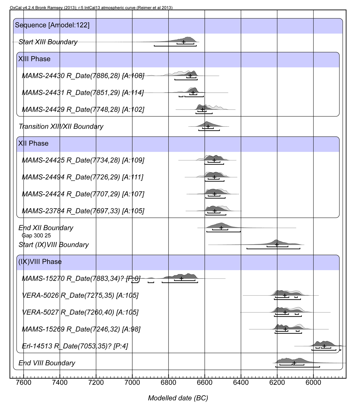
Figure 1. Çukuriçi boundary model.
| Boundaries | Cal BC (1σ) | Median |
| Start level XIII | 6760–6660 | 6720 |
| Transition XIII / XII | 6620–6550 | 6580 |
| End XII | 6560–6470 | 6510 |
| Start level (IX)VIII | 6260–6140 | 6200 |
| End VIII | 6190–6050 | 6110 |
Table 1. Çukuriçi model summary.
 up
upUlucak
This site's radiocarbon evidence (n=38, to date) is complicated, and simply sequencing the dates according to the phasing yields an unsatisfactory model with very low agreement (Amodel: 4) (Figure 2). Short-lived samples on emmer from level VI possibly stem from the same event or from a short sequence of events, and are combined using the Combine command. Likewise, two charred seed samples from level Vb with same provenance (KN-5782 and KN-5781) have been combined. Both are taken to represent the time of destruction of their respective levels. Constraining the data further, we assume a gap of about 100 years between levels VI and Vf, justified on basis of the dates but also assumable given the differences between both levels (Çilingiroğlu et al. 2012, 14).

Figure 2. Ulucak Late Neolithic–Early Chalcolithic boundary model, with assumed gap between Level VI and Vf.
By treating a couple of dates deviating from the general chronological and sequential tendency, the Ulucak boundary model can be upgraded just a bit (Amodel: 32; Figure 3).
—L.T.
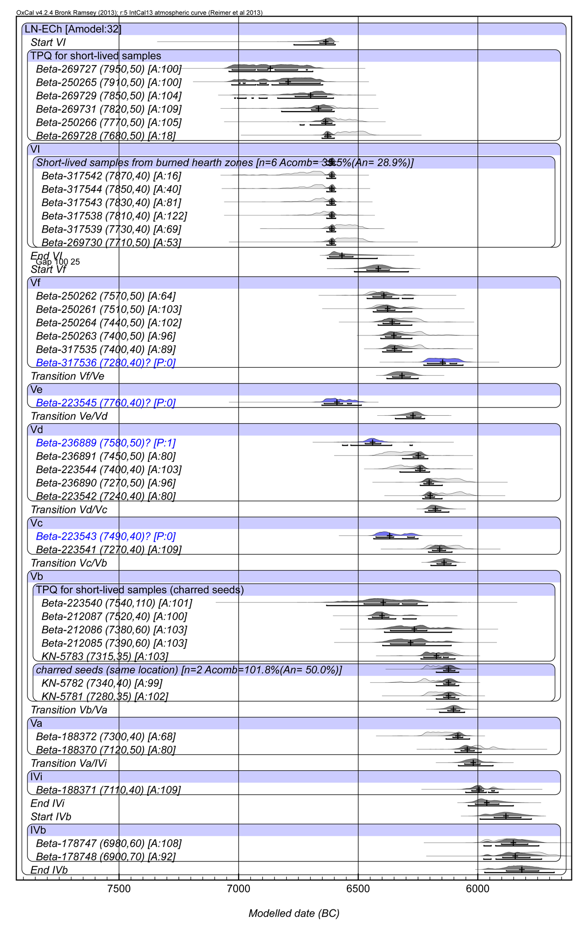
Figure 3. Ulucak upgraded boundary model, outliers indicated in blue.
Table 2 has the simplified rendering of the last model.
| Ulucak Boundaries | Cal BC range (1σ) | Median |
| Start level VI | 6670–6600 | 6640 |
| End VI | 6620–6520 | 6570 |
| Start Vf | 6470–6370 | 6420 |
| Transition Vf / Ve | 6360–6280 | 6320 |
| Transition Ve / Vd | 6300–6230 | 6270 |
| Transition Vd / Vc | 6210–6150 | 6180 |
| Transition Vc / Vb | 6180–6110 | 6140 |
| Transition Vb / Va | 6130–6070 | 6100 |
| Transition Va / IVi | 6060–5990 | 6020 |
| End IVi | 6020–5910 | 5960 |
| Start IVb | 5940–5820 | 5880 |
| End IVb | 5890–5740 | 5820 |
Table 2. Ulucak boundaries.
Ege Gübre
The site (also known under its older name Çakmaklı Tepe) has four main phases:
| Ege Gübre I | Hellenistic |
| Ege Gübre II | Late Chalcolithic |
| Ege Gübre IIIa | Early Chalcolithic |
| Ege Gübre IIIb | Late Neolithic |
| Ege Gübre IV | Late Neolithic |
Table 3. Ege Gübre main phases.
The excavator's remark that "most of the artefacts were found in the IIIa and IIIb levels" and that "Layer IV was mostly scraped away by the activities that took place during Layer III" (Sağlamtimur 2012, 198), could at least suggest that the reliability of the dates assigned to Layer IV is questionable, and their phasing more prompted by their age than their stratigraphic context. Simultaneously, this situation is hard to reconcile with the excavator's statement that "none of the architectural phases are to be found on top of each other [...]" (l.c.). The "500-year life span" (l.c. and p. 201), obviously based on an uncritical interpretation of the 14C evidence, is hard to imagine when the pottery is stated to be "rather homogenous" in shape and technology, and vessel types differ only in relative proportions between Layers IV and III. Impresso pottery seems to have been present in both levels in very low quantities (ibid., 200). The lithic industry is mainly on blades, produced at the site, and is dominated by flint, with obsidian much less used. Animal bones consist mainly of sheep, goat and cattle, "pig being underrepresented" (ibid., 201).
Most of the radiocarbon samples must have been collected from the central courtyard area (squares B2, C2, perhaps E1, E2 and D1, which are partly built), which had been used as a refuse area with a fill of 30–40 cm thick (ibid., 198); one sample stems from square E4, which is half covered by a segment of what is surmised to have been a stone protection wall erected against the repeated flooding of the Hayıtlı Çay. All dates are unidentified charcoal, therefore supplying termini post quos per individual level only (Amodel: 139; Figure 4). In contrast to the posited stratigraphic continuity, the two Level IIIa dates suggest a gap of at least a 100 years with preceding Level IIIb, which however doesn't alter the model very much (Figure 5).
If the Ege Gübre sequence and the dates are taken at face-value, the combined evidence makes clear that impresso pottery dates at least as old as the last century of the 7th millennium cal BC, and seems to continue into the 6th mill. The impresso pottery from a site like, e.g. Ilıpınar, where it first appears in Phase IX, to disappear again towards the end of Phase VIII, is therefore either an independent phenomenon, or else a late appearance of an earlier, Aegean tradition.
—L.T.
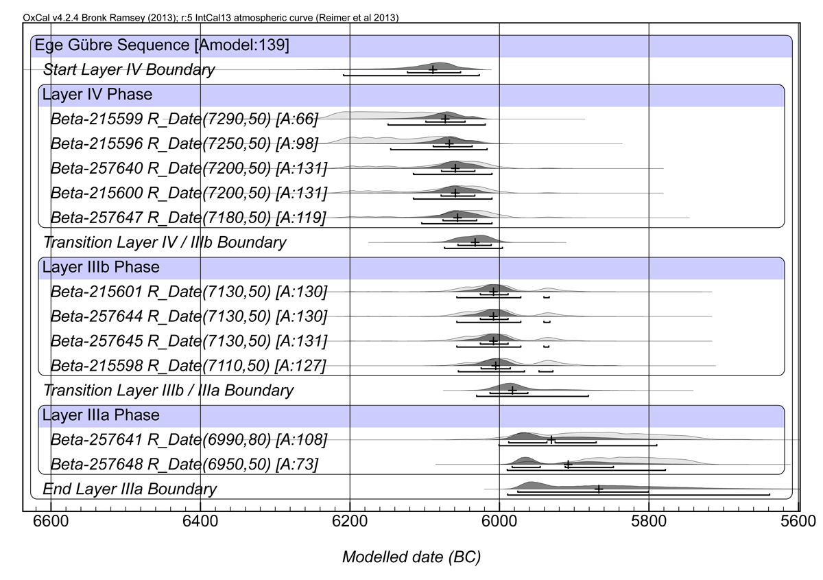
Figure 4. Ege Gübre boundary model.
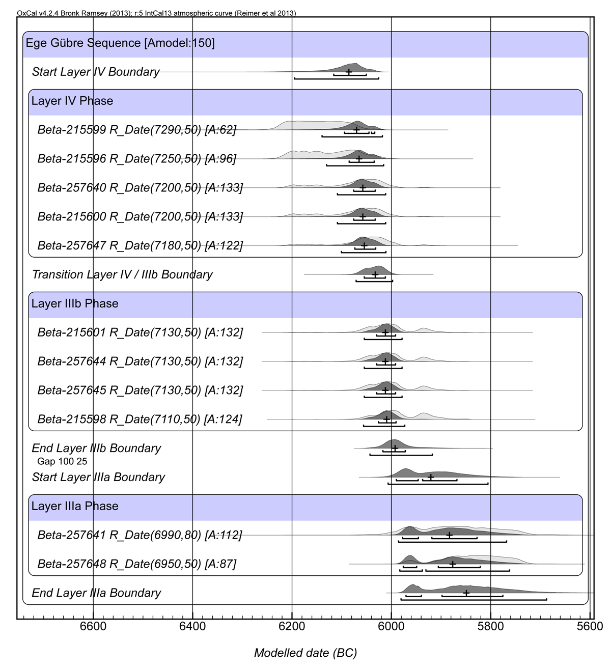
Figure 5. Ege Gübre alternative boundary model with hypothesised gap between Level IIIb and IIIa.